

1. Approach’s Outline and Features
This approach involves introducing how to monitor arid/semi-arid wildland fires through a Fire Early Warning System, which equips a region-specific Fire Danger Index (FDI) in sub-Saharan Africa and help manage forest and grassland resources sustainably.
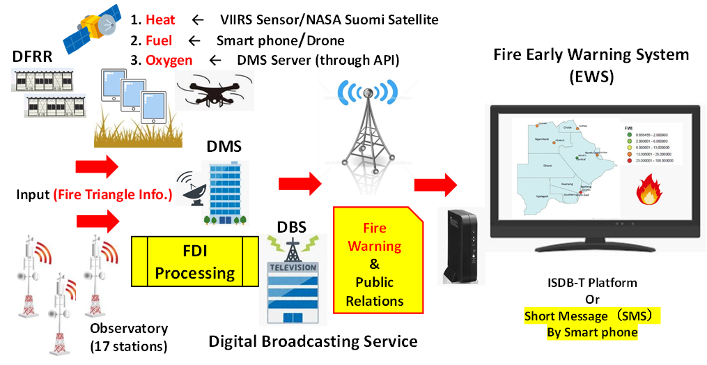
In sub-Saharan Africa, wildland fires can normally be spotted burning in the region each year from around April onwards. However, they tend to expand and intensify starting in August, fueled by dried-out vegetation and fanned by strong winds. These frequent wildland fires can indirectly lead to land degradation and it easily hinder the sustainable management of forests. Oxygen, heat and fuel are often referred to as the “fire triangle”. The key thing to note here is this: take any of these three things away and you will not have a fire or the fire will be extinguished. With this in mind, when developing the FDI, the region-specific “fire triangle” information should be taken into consideration as input parameters.
The fire early-warning system based on region-specific FDI will contribute to sustainable forest management (SFM) by helping prevent the incidence of wildland fires by distributing details of fire risks in advance via short message (SMS) to smartphones and tablet terminals.
Keywords
Arid/semi-arid, Fire Early Warning, Fire Danger Index, Forest and grassland resource,
2. Description of the project from which the approach is derived
2-1. Introduction
In sub-Saharan Africa, including Botswana, forests adjacent to urban areas frequently experience human-induced fires, e.g. those sparked by spreading flames after areas of agricultural land are expanded or charcoal and firewood collected. Although fire burning in arid and semi-arid areas is not necessarily always bad and indeed a crucial means of regenerating endemic species, frequent forest fires are known to degrade the land and weaken the soil, hindering the task of forest regeneration. The Government of Botswana, in technical cooperation with JICA, is working to develop a national forest and grassland master plan and also implementing some pilot activities, which include the abovementioned fire control activity to acquire knowledge on the actual site and strive to make it more practical by reflecting the insights and lessons learned to draft the national forest and grassland master plan.
2-2. Details of the measures taken
- The project involves developing the Fire Danger Index (FDI) algorithm on Google Earth Engine as the core engine of the Fire Early Warning System. The FDI will incorporate crude heat source data (Heat in “fire triangle”) and general combustible material distribution data (Fuel in “fire triangle”) by interpreting satellite imagery .
- Detailed data on the distribution of combustible materials (Fuel in the “fire triangle”) will be collected by local government offices using tablet PCs and used in the FDI to improve accuracy.
- Weather observation data such as precipitation, wind direction, wind volume, humidity, etc. (Oxygen in the “fire triangle”) will be sourced through the Application Program Interface (API) of the server managed by the Department of Meteorological Service (DMS).
- When the FDI exceeds the set threshold and reaches the level at which a fire warning alarm is issued (i.e. Catastrophic Danger, Extreme Danger), the alarm notifies the fire management stakeholders in the area via SMS or other means such as digital broadcasting service.
- A series of operation manuals are to be prepared on the flow of activities upon receiving the fire warning alarm, cooperation with local communities, fire control stakeholders such as local polices, intelligent security services in fire confirmation and firefighting activities.
(Perspectives on sustainability)
It is important to manualize a series of mobilization procedures, including actions taken by agencies involved and staffing, after receiving alert information by the Fire Early Warning System, not only developing the system itself.
3. Analysis of the approach
3-1. Impact
The Fire Early Warning System based on the customized Fire Danger Index, which incorporates region-specific information as input parameters, is a technology that can be widely replicated, not only in Botswana but also in neighboring countries (e.g. SADC Member States) and has the potential to be applied in other arid and semi-arid regions as an efficient means of controlling fires with limited personnel.
3-2. Lessons learned
- The Fire Danger Index (FDI) has been developed in Europe, the U.S., South Africa and other countries and we believe that it can be made even more accurate by customizing it to incorporate region-specific information such as local meteorological data and information on combustible materials as parameters.
- When considering the operation of the Fire Early Warning System, another effective approach is to utilize the latest forest distribution map/national forest inventory data to identify priority areas or points for conservation.
4. Relevant information
| NbS Approach Category | 2-1. 6 |
| Title of the project from which the approach is derived | Project for Capacity Development for the Conservation and Sustainable Use of Forest and Range Resources through the Process of Master Plan Development |
| Country | Botswana |
| Biome | Savanna |
| Implementing term | 2021/2/2 ‐ 2025/1/31 |
| Implementing organizations | Department of Forestry and Range Resources (DFRR) / Ministry of Environment, Natural Resources Conservation and Tourism (MENT) |
| Supporting organizations | Japan International Cooperation Agency (JICA), Japan Forest Technology Association (JAFTA), Nippon Koei Co., Ltd. |
| Report/Tool/Guideline | – |
| Contributors to this article | Takashi Nanaumi /JAFTA |